Solution
The procedures for registering your camera's location information in its images are explained below.
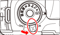
1. Set the power switch to <ON>.
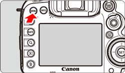
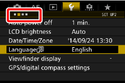
2. Press the <MENU> button to display the menu screen.
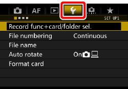
3. Press the <

> button and select the [

] tab.
4. Turn the <

> dial to select the [

] tab.
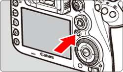
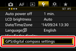
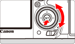
5. Turn the <

> dial to select [GPS/digital compass settings], then press <

>.
6. Select [GPS] and press <
>.
7. Turn the <
> dial to select [Enable], then press <
>.
8. 5. Press the <MENU> button to display the menu screen.
GPS signal status is indicated by the [

] icon on the LCD panel and on the shooting function settings screen.
Constant

: Signal acquired
Blinking
: Signal not acquired yet
6. Shoot.
When you shoot while [
] is displayed, the image will be geotagged.
NOTE
- To acquire GPS signals, take the camera outside where the sky is unobstructed. Face the top of the camera toward the sky while keeping your hands, etc., away from the camera top.
- When the signal acquisition conditions are good, it will take the camera approx. 30 sec. to 60 sec. to catch the GPS satellite signals after you set [GPS] to [Enable]. Check that [ ] is displayed on the LCD panel, then shoot.
- The camera can receive GPS signals even in the vertical orientation.
IMPORTANT
- If [Enable] is selected, < > will still be displayed on the LCD panel even when you turn the camera’s power switch to <OFF>. Also, since the camera will receive GPS signals at regular intervals, the battery will drain quickly and the number of possible shots will decrease. If you will not use the camera for a prolonged period, set to [Disable].
- The GPS antenna is built-in around the hot shoe. Although the GPS signal can be acquired while an external Speedlite is attached to the hot shoe, the acquisition sensitivity will slightly decrease.
- GPS Receiver GP-E2 (sold separately) cannot be used.
REFERENCE
Under the following conditions, the GPS satellite signal will not be properly acquired. As a result, the geotag information may not be recorded or inaccurate geotag information may be recorded.
- Indoors, underground, in tunnels or forests, between buildings, or in valleys.
- Near high-voltage power lines or mobile phones operating on the 1.5 GHz band.
- The camera is left inside a bag, etc.
- When traveling a long distance.
- When traveling through different environments.
- Since GPS satellites move as time passes, satellite movement can interfere with geotagging and cause missing or inaccurate geotag information even in conditions other than the above. Additionally, the geotag information may also include the route travelled even if the camera was used only at one location.