Solution
To acquire GPS signals, bring the camera outdoors where the sky is unobstructed and aim it upwards. Keep your hands and other objects off the top of the camera.
1. Set the power switch to <ON>.
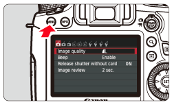
2. Press the <MENU> button to display the menu screen.
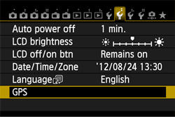
3. On the [

] tab, select [GPS] and press <SET>.
5. Set [Select GPS device] to [Internal GPS] and press <SET>.
6. The following screen appears.
7. Press the <MENU> button to exit the menu.
GPS signal status is indicated by the <

> icon on the camera’s LCD panel and LCD monitor.
- Constant <
 > : Signal acquired
- Blinking <
 > : Signal not acquired yet
NOTE
- When you shoot while the <
 > mark is lit, the image will be geotagged.
- When [Internal GPS] is selected, the <
 > mark is displayed on the camera’s LCD panel even when the camera’s power is turned off because signals from satellites are constantly received. Also, the number of possible shots will be lower, since it will consume more battery to receive satellite signals.
- Status details can be checked as described in "Viewing GPS Information".
- Under favorable conditions, signal acquisition takes approx. 30-60 seconds after turning on the camera if radiowave conditions are good.
- The antenna of the internal GPS is located at the front of the hot shoe. GPS signals can be received even when an external flash is attached. However, acquisition will slightly be weakened.
- GPS signals can be received even when shooting with the camera positioned vertically.
- When traveling long distance, inaccurate information may be recorded.
CAUTION
Location information may not be recorded, or inaccurate information may be recorded where GPS signal coverage is poor, such as in the following locations.
- Indoors, underground, in tunnels or forests, near buildings or in valleys.
- Near high-voltage power lines or mobile phones operating on the 1.5 GHz band.
- When traveling through different environments.
- Even in other locations, satellite movement may interfere with geotagging and cause missing or inaccurate location information. The information may also indicate that the camera has been used in a different location, even if you are shooting at the same place.
1. Set the power switch to <ON>.
2. Press the <MENU> button to display the menu screen.
3. On the [

] tab, select [GPS] and press <SET>.
4. Set [Select GPS device] to [Internal GPS].
When using the GPS Receiver GP-E2 (sold separately), select [External GPS].
5. Select [Set up] and press <SET>.
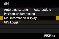
6. Select [GPS information display] and press <SET>.
Detailed GPS information is displayed.
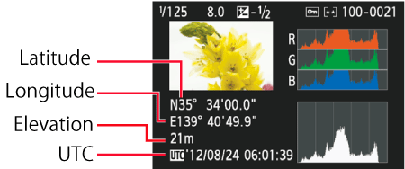
[UTC] (Coordinated Universal Time) in this sample screenshot is essentially the same as Greenwich Mean Time.
The icon <

> indicates signal conditions. When <3D> is displayed, elevation can also be recorded. However, elevation cannot be recorded when <2D> is displayed. Generally, elevation is not as accurate as latitude and longitude due to the characteristic of GPS.
7. Take a picture.
- Shots taken after GPS signal acquisition are geotagged.
The screen below is displayed when pressing the <INFO.> button several times during image playback.
REFERENCE
-It is recommended to attach an external GPS to the hot shoe. When [Wi-Fi] on the [

] tab is set to [Enable], interface cable connection to the external GPS is disabled.
- Note that if you play back an image with GPS information shot with another EOS 6D (WG) camera, GPS information is not displayed on the camera’s playback screen. Shooting locations can be viewed on a virtual map, using the Map Utility software.
NOTE
During movie shooting, information at the start of shooting is recorded. Note that signal reception conditions are not recorded.

 ] tab, select [GPS] and press <SET>.


 > icon on the camera’s LCD panel and LCD monitor.
 > : Signal acquired
 > : Signal not acquired yet
 > mark is lit, the image will be geotagged.
 > mark is displayed on the camera’s LCD panel even when the camera’s power is turned off because signals from satellites are constantly received. Also, the number of possible shots will be lower, since it will consume more battery to receive satellite signals.
 ] tab, select [GPS] and press <SET>.


 > indicates signal conditions. When <3D> is displayed, elevation can also be recorded. However, elevation cannot be recorded when <2D> is displayed. Generally, elevation is not as accurate as latitude and longitude due to the characteristic of GPS.
 ] tab is set to [Enable], interface cable connection to the external GPS is disabled.